
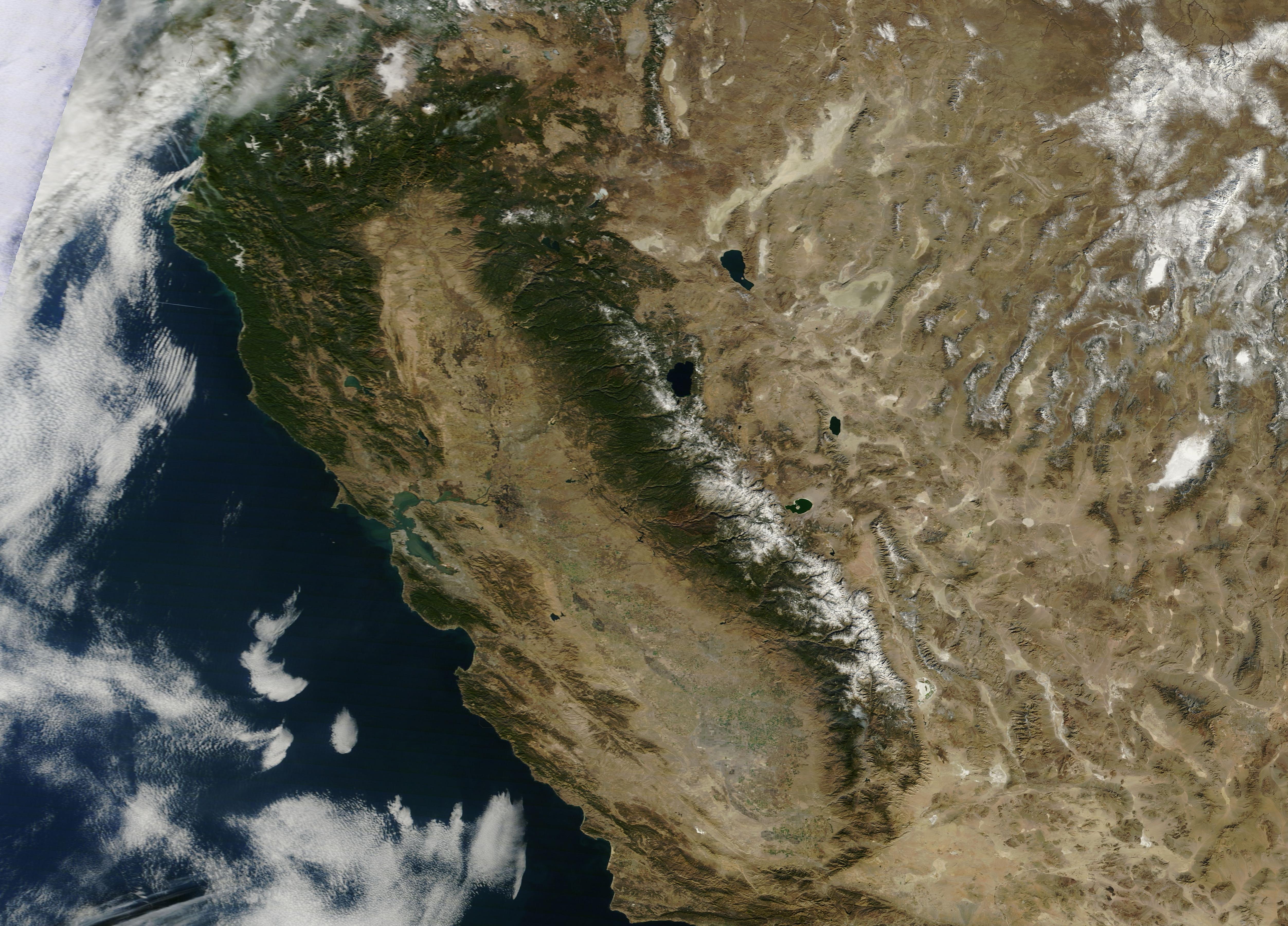
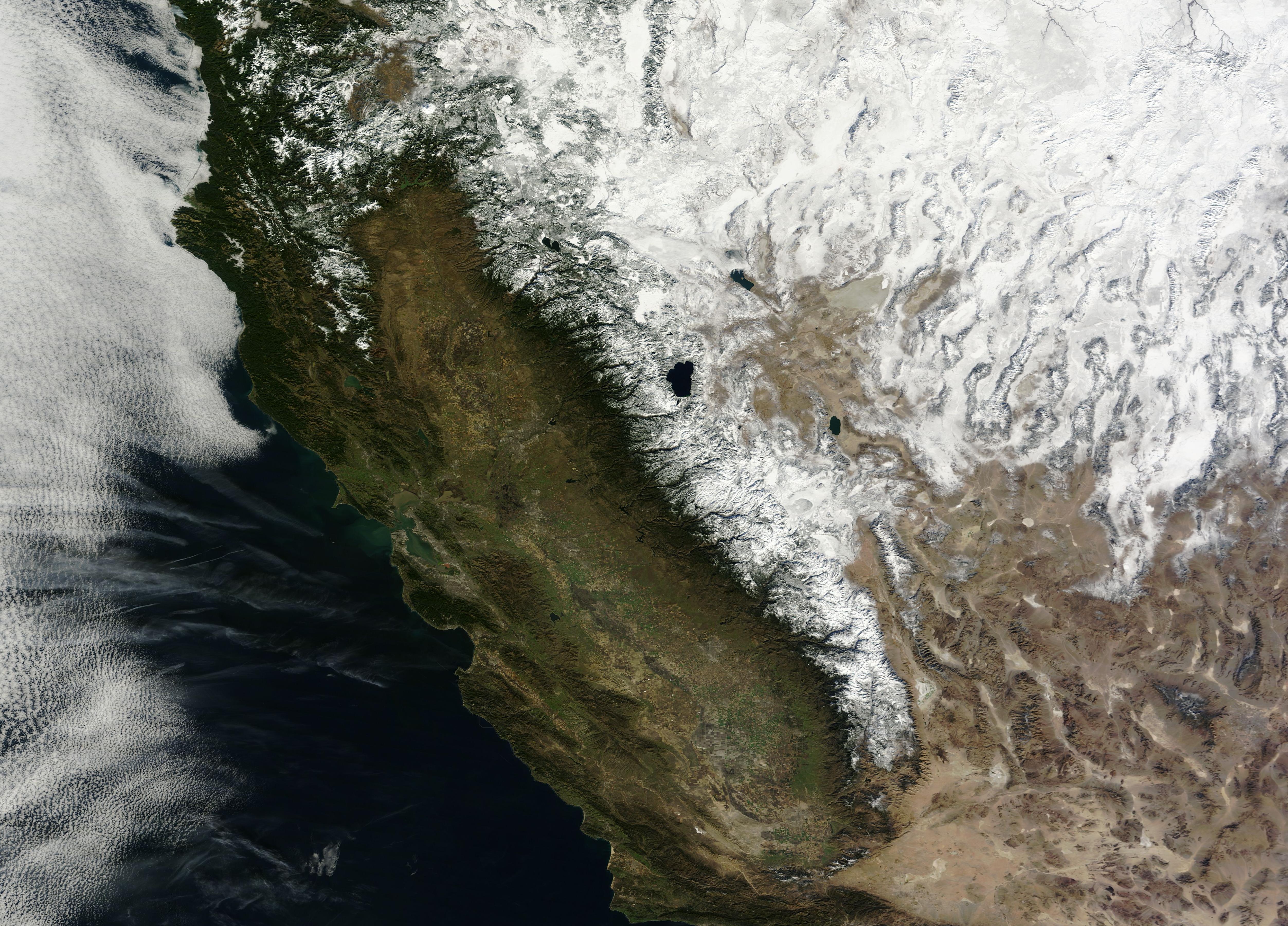
NASA released two images on January 23, 2014 through their excellent Earth Observatory site. The images compare California and Nevada on the same dates in 2013 and 2014 as seen from space. The images graphically illustrate the severity of the drought situation in the region. See this link for full story. The Moderate Resolution Imaging Spectroradiometer (MODIS) on NASA’s Terra satellite obtained the images on January 18 of each year. This first image is from 2014. The second is from 2013. Click each one for an enlargement of 10x.
LANCE/EOSDIS MODIS Rapid Response Team at NASA GSFC
LANCE/EOSDIS MODIS Rapid Response Team at NASA GSFC
What stands out is the lack of snow cover in the mountains in 2014. It is 10 to 30% of normal. Some areas have none. California gets 1/3 of its water from snow. Another feature less visible is the light tan color of the top 2014 image in the growing regions of the Sacramento and San Joaquin Valleys. It indicates the absence of vegetation. Normally, this region gets half of its precipitation between December and February. The region is on track to be the driest on record in the coming months.
The article in Earth Observatory provides a convenient tool to easily compare the two images. Here is a short video showing how that tool works. Watch it, then go to the article and try it yourself.
For California in particular, this chart illustrates their problem. The blue line is the normal precipitation pattern. It rises to 3-4″ values during the winter months and falls to less than 1″ in the summer. The red bars indicate actual precipitation has been below normal values. Each of the recent winters show below normal precipitation in the normally wet time of year. Governor Brown issued a state of emergency January 17 urging citizens to conserve water.


[…] via Drought 2014 | CA and NV Satellite Views. […]
Excellent work Jim, and illustrates the need for everyone, not just those in CA, to conserve water. Here in south Texas we’re no strangers to drought.
Thank you, Alex. I remember a few years ago the extreme drought in your area. Has that area returned to ‘normal’?
According to NOAA, we are in the process of returning to normal, not quite there yet.
Because of recent drought, the Highland Lakes in central Texas, which are the main source of water for the Austin metropolitan area, are down to about 1/3 of capacity—and we still have our half-year of summer ahead of us. I find that scary.
There’s an article at
http://en.wikipedia.org/wiki/Desalination
that lays out the basics of desalination. One sentence caught my attention:
“Supplying all domestic water by sea water desalination would increase US Domestic energy consumption by around 10%, about the amount of energy used by a domestic refrigerator.”
I don’t know if that’s accurate, but if it is, then massive desalination seems well worth the cost, especially since the prospect of extensive and extended drought is so disastrous.
It might also make economic sense to build some large pipelines to bring water from places where it’s abundant, like northeastern North America, to places where it’s not, like the Southwest.
I think it’s easier to sell people on technological approaches than it is to persuade them to give up their obsession with water-hungry lawns in regions where that’s unnatural (like mine, for example).
Drought and water supply is going to be an increasingly complex problem. It will rival oil and fossil fuels in disputes. Can you imagine running a pipeline across country? The Keystone oil pipeline is a case in point.
I don’t know the answers. But, we will all face some tough choices and lifestyle changes over both areas.
Great images delivering frightening information. Scary when you think about what this year’s forest fire season could be like.
Let’s hope for some well-time rains and snows that come by surprise out of season.
[…] air heads into California, Oregon, Washington, and British Columbia giving them their rainy season. Not so this year or last winter. As a result, California is in an extreme drought […]
[…] the wettest. Instead, the red bars indicate below normal amounts each year. One year ago, I wrote about this situation. The much needed precipitation is not […]