

wikipedia commons
My Good Friend Bob then asked if we would visit the Four Corners region when we traveled in the southwest. GFB then added that there is a monument to designate the landmark where the boundaries of Arizona, Colorado, New Mexico, and Utah meet. He told me the marker for the monument is in the wrong place.
I told GFB that it was not likely misplaced by very far. Besides, what would it hurt to be off a few inches? GFB laughed and said it was off by several miles. He would send me some information to read about it.
It peaked my interest to hear GFB tell about this. There are many ‘urban legends’. This might be another one that could easily be de-bunked by some science and facts. His claim made me remember a TV episode we watched the week before.
We’ve been unhappy with the cost of our satellite TV service. Our habits have changed and we don’t watch much any more. It was too expensive to buy and not watch anything. We cancelled it and started with Roku and our antenna for local channels. During exploration of Roku offerings, we came across a show How The States Got Their Shapes. We watched the episode about a border dispute between Georgia and Tennessee. More about that later.
GFB sent me the article right away about the Four Corners monument mistake. It is from the National Geodetic Survey.gov and should be accurate. It is kind of wordy and technical and the format is hard to read. I will summarize for you.
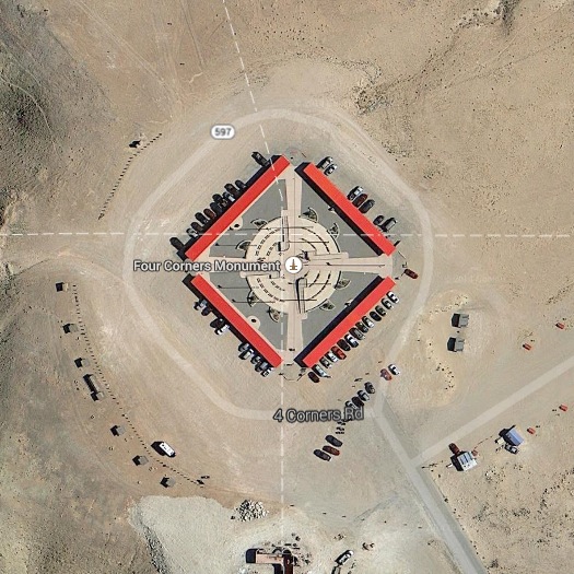
Four Corners Monument | Google Maps
Chandler Robbins was contracted in 1875 by the U.S. General Land Office to survey the boundary between the Arizona and New Mexico territories. He was to survey from the U.S.-Mexico border to the 37th parallel of latitude north of the equator. The 37th parallel defines the southern border of Colorado and Utah. The terminus of the survey by Robbins and the 37th parallel would be known as the Four Corners monument. President Lincoln had signed an 1863 Act of Congress specifying the AZ-NM boundary along the 32nd meridian of longitude west of the Washington (DC) Meridian.
The Washington Meridian passed through the dome of the old Naval Observatory 77 degrees and 03 minutes west of the Greenwich Meridian. It wasn’t until 1912 that the U.S. adopted Greenwich as its standard longitude reference. Congress had therefore specified the monument to be 77 degrees and 03 minutes plus 32 degrees west of the Washington Meridian. That is 109 degrees and 03 minutes of longitude. Many people assumed it was to be in reference to Greenwich placing it at exactly 109 degrees west. That 03 minutes translates into about 2.5 miles farther west than many people thought was correct.
Chandler did as he was directed with the best available technology of his day. He knew of the controversy. In fact, he wrote to the Santa Fe New Mexican paper November 1, 1875 and said:
It seems to have been the general impression that the line was the 109 degrees of longitude west of Greenwich. Such is not the case, as the law makes it 32 degrees of longitude west from Washington, which corresponds to 109 degrees 02 minutes 59.25 seconds west from Greenwich, and which places the line a small fraction less than three miles farther west than would have been the case if it had been run as the 109 degrees of longitude.
Using GPS systems today, we find the Four Corners Monument is not 2.5 miles west of the 109th longitude. It is more likely 1800 feet east of it. And, all of those technical geodetic details are moot. The monument marks the exact spot where the four states meet. When the monument is placed and the parties legally agree to it, the monument is the ultimate authority about a boundary. Legality trumps scientific details. In surveying, the monument location rules over all disputes.
Many thanks go to my GFB for leading me to this interesting story and piece of history. I can always count on GFB for something to make me think. GFB…this post is for you.
Other Stuff
•• For a Google Maps view of the Four Corners monument, follow this link.
•• For an audio explanation from NOAA, listen to this recording. Move the slider to the 04:30 time.
Another Boundary In Question
Now back to the TV program about the shapes of the states. The program is part of the History Channel from 2011. This 3 minute clip explains some of the issue whereby Tennessee and Georgia have a disagreement about the location of a border which controls some water rights that Atlanta is interested in settling. Note how the surveyor answers the question of whether the border is in the wrong place. There is a short ad.
Back in September 2013, the Daily Show with Jon Stewart sent Al Madrigal to check into this same border question. As you might expect from the Daily Show, it was poking fun at the situation. Caution to readers. There is content you might find offensive. Here is a link to the segment of the show. There is a short ad.

Very interesting tidbit … and the Tenn-Ga border video helps explain. … .and thanks for stopping by during my absence.
I hope the move is going well. It is a big disruption.
Not big … maybe huge or ginormous … but not big. 😉
Yes…’big’ is a relativistic term…the ‘Big Bang’…the ginormous bang. 🙂
🙂
As a surveyor, this is a great article. The rules of construction and boundary law is a fascinating (and frustrating) aspect of the profession. If you want read something interesting (or sleep inducing, depending on your interests) check this article out. Good stuff Jim.
http://www.pobonline.com/articles/97210-breaking-down-the-rules-of-construction
I will take a look at that article. Thanks for your comments. You know what it is all about.
That article went into great detail. The issues and conflicts can be numerous. Thank you for attaching it.
Interesting. I watched the whole series about how the states got their shape. Great series!
I agree. There is a lot of history there. We could use more shows like that.
Thank you for stopping by.
Very interesting read. In the end like you said it all comes down to what the parties legally agree to.
I enjoyed your Four Corners post, Jim. It did leave me wondering about the possible ramifications for towns along the Arizona/New Mexico border, so I got my road atlas out and looked. The only thing close was some village on the Indian reservation and that was several miles away. The cactus and jackrabbits don’t care.
As a maritime navigator I note that land surveyors have a big edge on positioning. I was navigating well before GPS and when away from land an accuracy by sextant of a mile or three was good. Even near land it was tricky because gyro compasses have errors, silt flows, buoys break away and drift and weather limits visibility. And charts have errors and omissions. Now, with GPS, I confess to a bit of scorn for the ease it must make for sailors. But one thing hasn’t changed: human error. Case in point: the ship and oil barge collision in Texas. What a mess that is, including the two HUGE cruise ships needing to get back to Galveston. Who pays when that happens?
Thanks for checking along the border. Good to know there is little if any impact. I doubt if the jackrabbits will change their habits.
I would like to be able to navigate by sextant and clock. It would be good to know the skill. Then, I would always rely on GPS to increase my odds of living longer.
The mess in G-ston is awful. I suppose we all pay in some ways for the mistakes. Some of us pay in $$. The cost to the environment is huge. How disappointing.
Thanks for coming by today. I got back kind of slow as I was teaching a class to some folks about how we know the distances to things out in space. That was fun. http://wp.me/p3iF5r-2L
I’ve heard there is some dispute about the IA-MN border, too. Some people on the Minnesota side wouldn’t mind moving the Iowa border farther north, as they’re tired of the long Minnesota winters. 😉
Yes. I’ve heard about that, too. 🙂
Thanks.
The border disputes–and how state boundaries were determined–is fascinating.
Ah yes, relativity. I seem to recall that in some American Indian language(s) the statement “I’m lost” doesn’t make sense: the speaker can see where he is, but the place he’s trying to get to may be “lost.”
That makes sense.
Nice case study. Who knows, perhaps in time as the continent moves due to plate tectonics the border may make more sense. Or less.
Your comment about getting rid of your satellite service explains all that rummaging around you’ve been doing in shirtsleeves outside. I can understand giving it up, with so few worthwhile things to watch. Even many “educational” channels have turned to entertainment, like reality shows. I’m tempted to cut off my satellite tv, but am stuck at present with poor bandwidth – optimally I’d watch my few shows on the computer. Rooftop antennas don’t pick up any stations any more since the switch to digital. There are very few downsides to living in a rural area, but electronic access is one of them.
Given enough time, plate tectonics will rearrange a lot of borders. Let’s hope the ones on the west coast occur slowly, not in lurches.
You are right about the rummaging outdoors remark. I removed some ugly cables from the dish that ran along the siding to the corner where they came into the house. Black against tan was not so attractive. If I ever go back, they can restring them. Dish sent me an empty box with a shipping label to return the hardware from the living room.
We have found plenty to watch if we want. Now, if we choose to not watch, it doesn’t cost much.
Our antenna is in the attic space. It’s the same one we used before the digital switch to HD over the air. They still work. You need either a TV with the correct tuner. Or, a decoding box to convert to a signal for an older model TV. That all assumes you get a strong enough signal in the first place. Maybe you don’t even get that.
Oh my, the education channels have gone to hell. TLC and the Discovery channel used to have good shows. Not any more.