
November 13, 2012 provided solar eclipse watchers an opportunity to see one pass the northern coast of Australia. Unfortunately, the umbra only crossed two peninsulas and not the mainland. Residents and eclipse chasers had relatively few locations where viewing was optimal. For some, it was quite a challenge. This map from NASA Eclipse Web Site run by Fred Espenak shows the eastward progress of the umbra across the Pacific ending before it reached Chile. It made no more landfalls.

One small group of chasers had as their goal to launch a helium filled balloon with an HD video camera and other instruments on board to record the eclipse from several miles up in the stratosphere. Their story was published in the October 2013 issue of Sky and Telescope magazine. This post briefly summarizes their quest. Their HD video is at the end.
Co-authors and leaders of the project team are Romanian journalist Catalin Beldea and Australian Joe Cali. Both are avid eclipse chasers. Their names are hyperlinked if you wish to see examples of their work at their web sites. More details from Cali about this story are here. He details much of what went into the S & T magazine article.
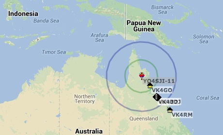
The location of their balloon launch was to be in the middle of Cape York Peninsula in the north of Queensland indicated on this map by the balloon icon. The total eclipse phase started just to the west near the Northern Territory. This is not a very populated part of the Outback. Roads are few.
They travelled during the day before eclipse and set up camp. By 3:30 am the morning of totality, they started to make preparations for the balloon launch. Things were going well until they ran out of helium from the tank. It only supplied 145 of the expected 215 cu ft of gas they expected. That reduced lift considerably. They decided to remove about half of the equipment for experiments leaving the HD camera and minimal other items.

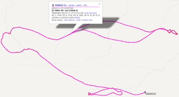
At 5:27 am they were able to launch and confirm the ascent rate was the expected 19 ft/sec. The balloon’s position was recorded on board. It also transmitted location data every few minutes for tracking. Full tracking information is available at this link. Here is a screenshot. The label shows the balloon location several minutes after launch at an altitude of 37,858 ft. It travelled east and a little south, turned around and headed back west as it went higher into a different layer of winds. It eventually turned south and then east again. This track is 3 hours long. It reached an altitude of 23 miles before it burst and parachuted down the camera and equipment.
While it ascended, the balloon passed through the umbral shadow of the Moon between 79,000 and 82,500 ft. The video camera was able to capture the event as it slowly rotated with the motions of the balloon in the atmosphere. Remember, the Sun was very low in the early morning sky. The shadow of the Moon was projected in a more horizontal east-to-west direction, not straight down to the ground as you might imagine for a mid-day eclipse. As you watch the video below, keep in mind the shadow is projected toward the horizon when it becomes most noticeable.
Another thing to watch for is the burst of the balloon around 7 minutes. Pieces are seen flying away. The package gets caught by the parachute and is gradually brought down 45 minutes later. Unfortunately, it got caught in a 60 ft tall tree which it a challenge to recover.
I hope you enjoy their video. It is a view of a solar eclipse few have ever seen.

What a great video … just like you said … a view few has ever seen. Loved the return fall!
I’m glad you liked it, too. I read the story and went to the url suggested by the magazine editors. It was amazing. Everyone should see this.
See you later…
In the late 60s we would’ve called this video trippy.
Yes, I can see why. 🙂